
Severe storms, heavy rain will cause additional flooding. Get Bill Steffen's weekday forecast
Strong storms will roll in Monday night and will stay through Wednesday.
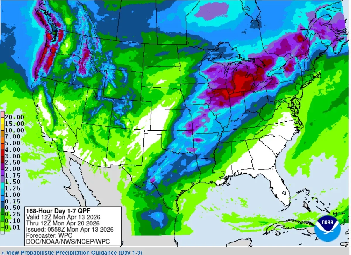
The Weather Prediction Center is forecasting the heaviest rain to be in Lower Michigan, northeast Illinois and northwest Indiana. The bright red is 2-3 inches. That’s on top of already wet ground, which would certainly produce more flooding. Fortunately, most rivers (including the Grand River in Kent County) have crested and have been falling over the last 24 hours.
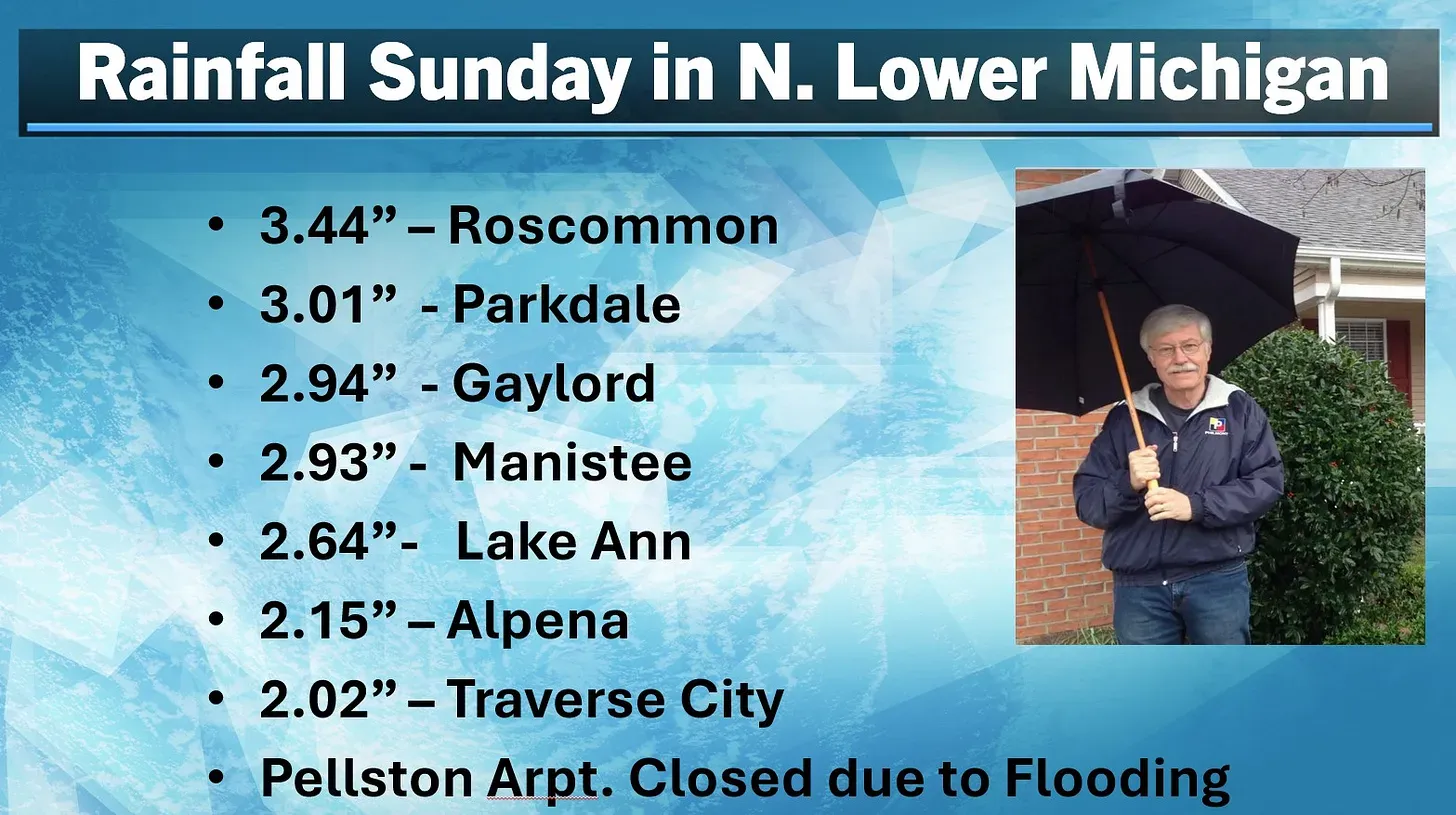
Look at the rainfall across N. Lower Michigan. Significant flooding was noted on the Crooked River and the water from Black Lake was approaching homes along the lake.
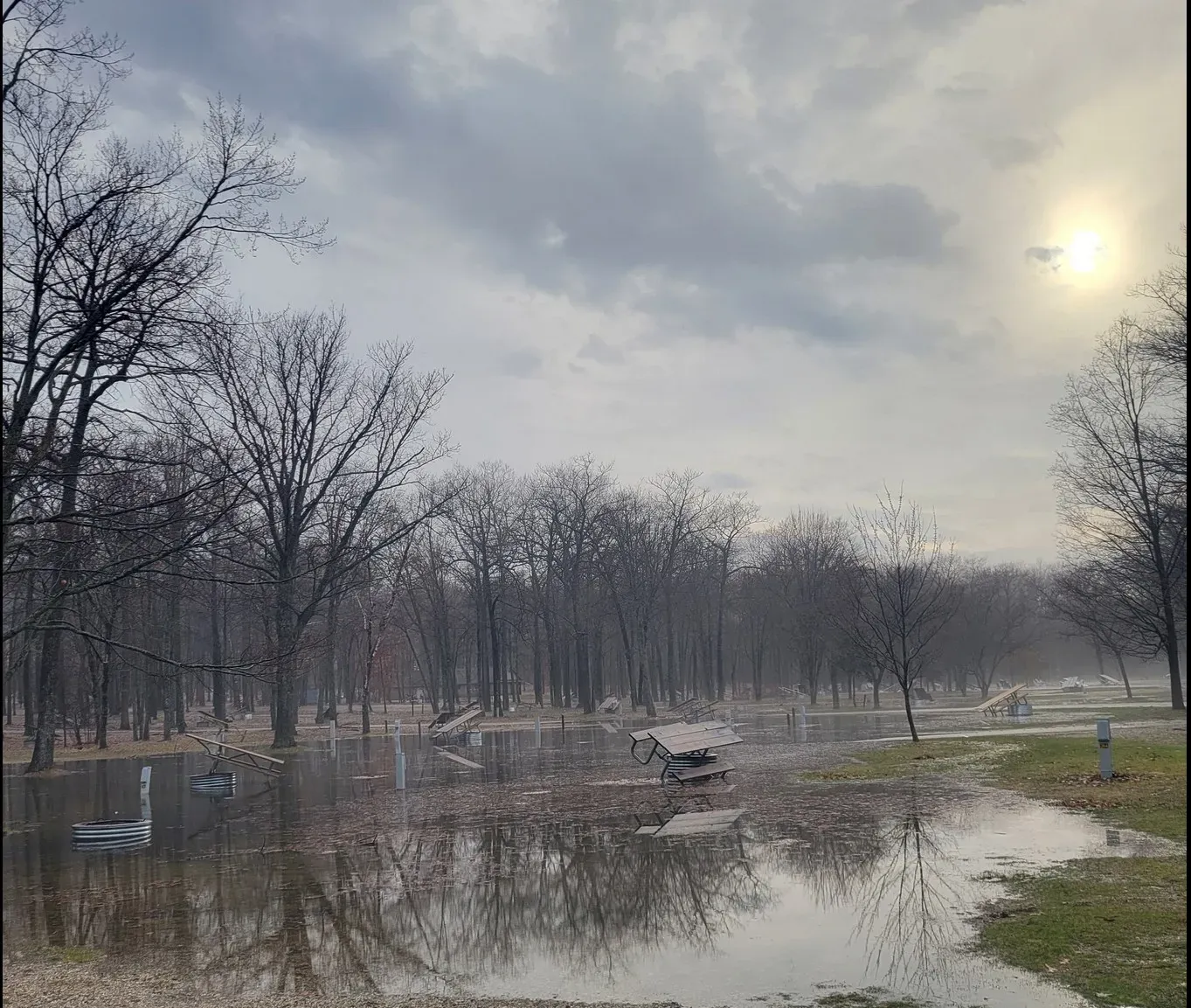
This is flooding at South Higgins Lake State Park (from their Facebook page). This is going to get worse before it gets better, unfortunately.
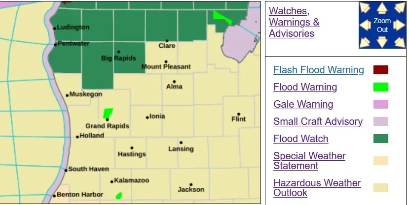
There’s a Flood Watch in effect for Oceana, Newaygo and Mecosta Counties to the north.
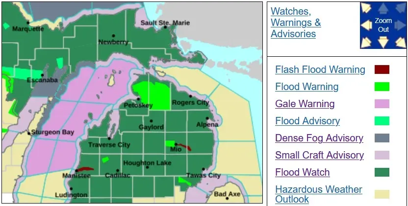
The Flood Watch covers all of northern Lower Michigan with a Flood Warning for most of Cheboygan and much of Emmet Counties. Here’s flooding in Cheboygan County.
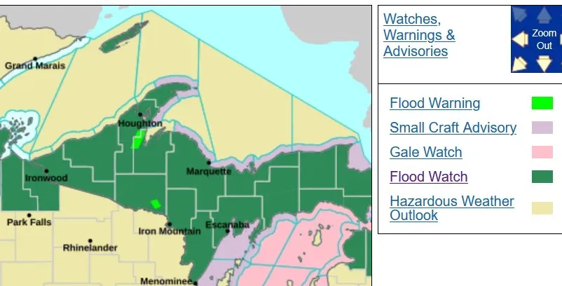
All of Upper Michigan is under a Flood Watch. At midnight, the Marquette Airport still had 33 inches of snow on the ground.
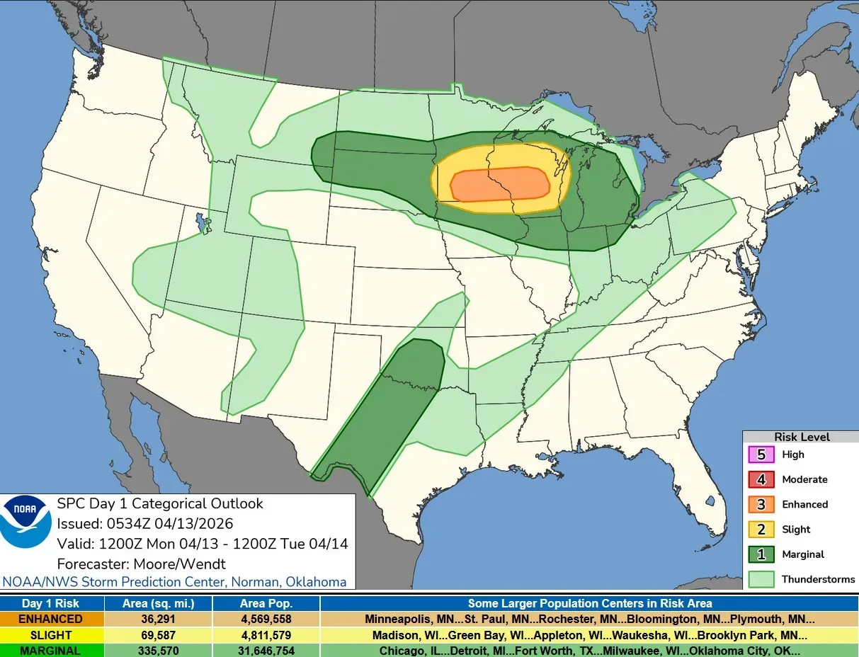
Here’s the Severe Weather Outlook from the Storm Prediction Center. Lower Michigan is in the dark green Marginal Risk Area. SPC says: “Severe thunderstorms are likely across the Upper Mississippi Valley and Great Lakes region with potential for large to very large hail, damaging wind, and tornadoes.”
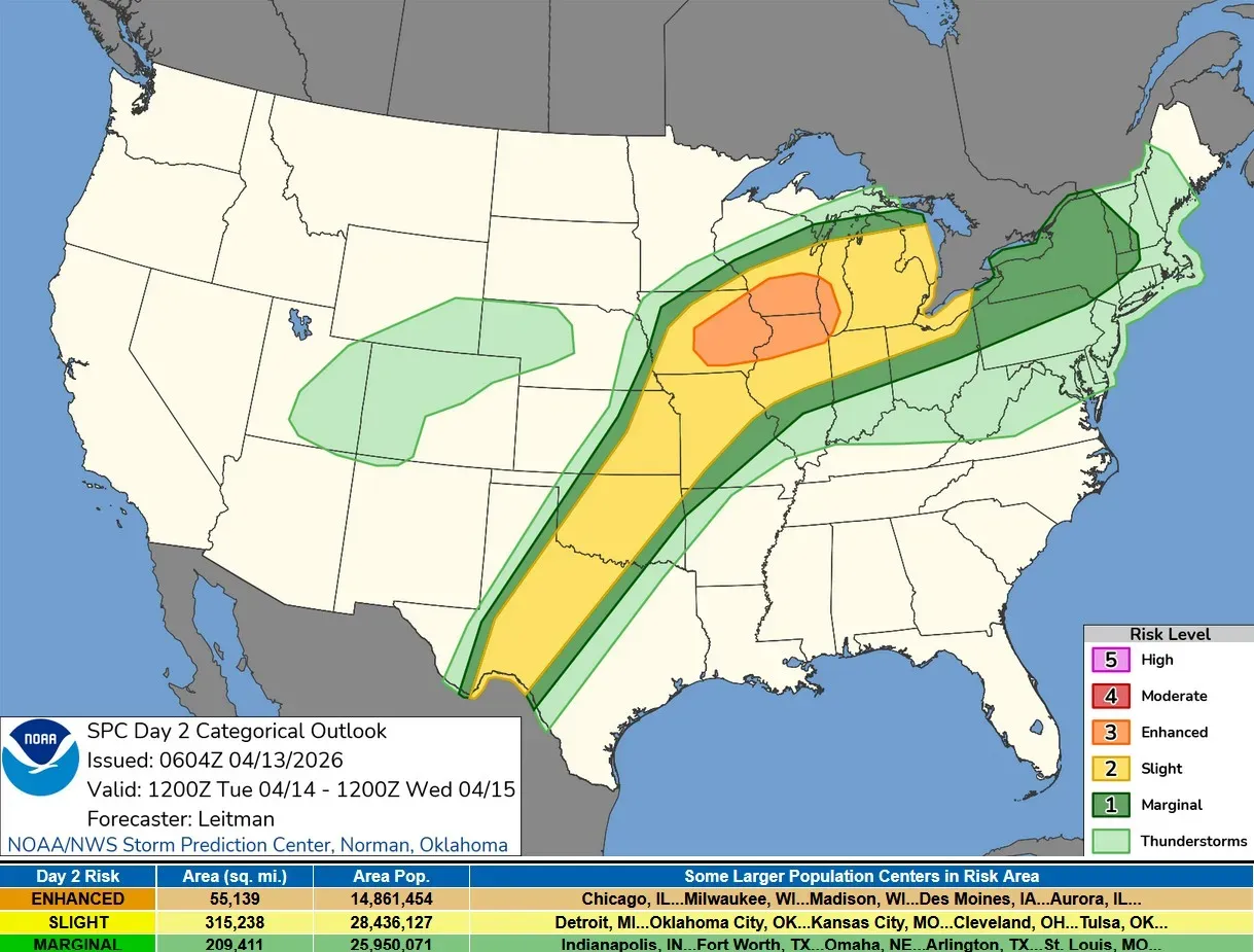
Tuesday PM, most of West Michigan is in the level 2 or Slight Risk Area (yellow on the map above) SPC says: “With time, and as the low-level jet increases during the evening, convection may consolidate/grow upscale into one or most bowing segments and progress eastward into Lower MI/IN/OH, posing a continued risk for hail and an increasing risk for damaging wind gusts.”
Winds will die down a little bit today. Peak gusts Sunday included 51 mph in Grand Rapids, 49 mph at Muskegon, 48 mph at Holland, 47 mph at Norton Shores and 46 mph at Battle Creek. I was at Manhattan Park in East Grand Rapids.
High temperatures Sunday included 82 in Detroit, 80 at Kalamazoo, Benton Harbor and Allegan, 79 in Grand Rapids, Battle Creek, Ionia, Marshall and Coldwater, 78 at the Holland Airport, 73 in Fremont, 66 at Ludington and just 37 at Sault Ste. Marie.
5-day forecast
- Monday: Fog will lift this morning, and it will be windy and mostly cloudy. Thunderstorms will move in this afternoon. Expect a high temperature of 66 degrees and a low of 55 degrees. Tonight, thunderstorms could be severe with hail and damaging winds.
- Tuesday: Windy with intervals of clouds and sunshine, with a high of 67 degrees and a low of 51 degrees. In the afternoon, expect strong thunderstorms with strong wind gusts and heavy rain.
- Wednesday: Cloudy with a couple of showers and a heavy thunderstorm. Watch for flash flooding, hail and localized damaging wind gusts. Expect a high of 61 degrees and a low of 51 degrees.
- Thursday: Windy and cooler in the morning with a chance of thunderstorms. Expect a high of 61 degrees and a low of 44 degrees. Mostly cloudy in the evening.
- Friday: Partly sunny and warmer, with a high of 73 degrees and a low of 55 degrees. The evening will be mostly cloudy and windy with periods of rain and thunderstorms.
— Check out Bill Steffen's Substack channel.


