
WINTER WEATHER RETURNS: Bill Steffen's weekend forecast: March 13-15
Get your weekend weather forecast right here!
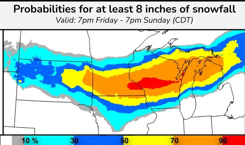
Two quick storms will bring heavy, blowing and drifting snow, very strong wind and treacherous travel throughout the Midwest and Great Lakes. The above graphic shows the probability of over 8 inches of snow. The red area is a 90% chance — a virtual certainty — for parts of southeast Minnesota and central Wisconsin. There is a large 70% likelihood from eastern South Dakota to northern Lower Michigan, including Traverse City, Cadillac, Gaylord and Mackinac Island.
This storm will bring a lighter mix of precipitation to much of the rest of Lower Michigan, along with very strong winds. There will be a brief lull in the storminess on Saturday before the true Arctic air arrives. It’s going to be significantly colder on St. Patrick’s Day than it was on Christmas!
The second storm will likely be worse than the first. The Gaylord National Weather Service writes: “If current trends do indeed hold, parts of Northern Michigan could easily see snow amounts well in excess of a foot by later Monday, and unfortunately, significant amounts of freezing rain as well. The first wind event is today (Friday) and then the 2nd wind event would be Saturday night into Monday.
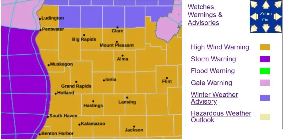
The tan counties are under a high wind warning today for steady winds of 25-35 mph and peak gusts of 50-60 mph. Winds this strong can bring down tree limbs and we could see isolated power outages. It’s best if you don’t park your car under a tree if possible.
Monday looks like another very windy day. The purple over Lake Michigan is a Storm Warning. (That’s one step above a Gale Warning and one step below a hurricane warning.)
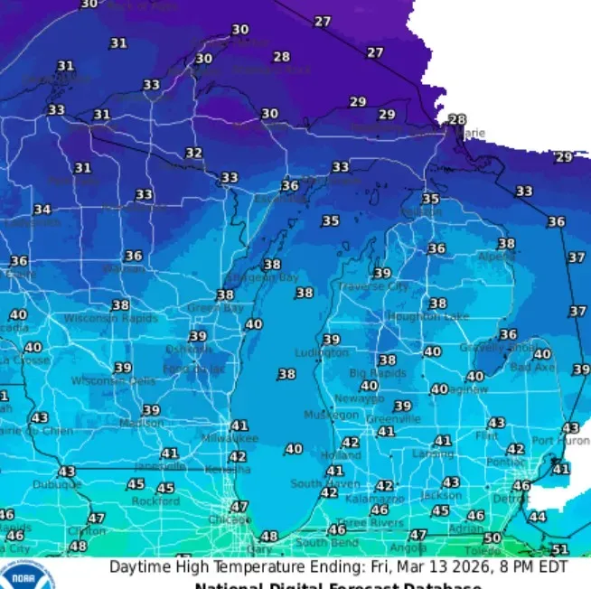
Let’s take a look at high temperatures for the next few days. Above is today (Friday), with lows in the 40s (mid- to upper 40s at the Indiana border). Temperatures will fall to the mid-30s by sunset, and the wind will make it feel colder than these temperatures indicate.
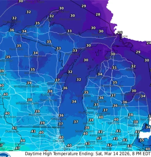
Saturday (above), there will be highs near 40 degrees, and the wind won’t be nearly as strong compared to Friday. With fresh snow, you might want to get the skis or snowmobile out one more time. Here’s ski resort conditions. Ski resorts in the U.P. are open, and northern Lower Michigan and the U.P. will have enough snow to run the snowmobile.
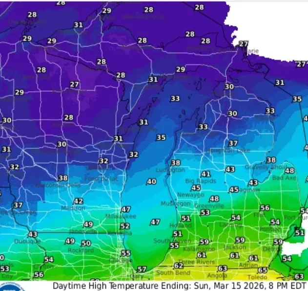
Here are the high temperatures for Sunday (above). The “warm air” makes a relatively brief run into southern Lower Michigan. It could reach the mid-60s at the Indiana and Ohio border and hold in the 30s at Ludington and Baldwin.
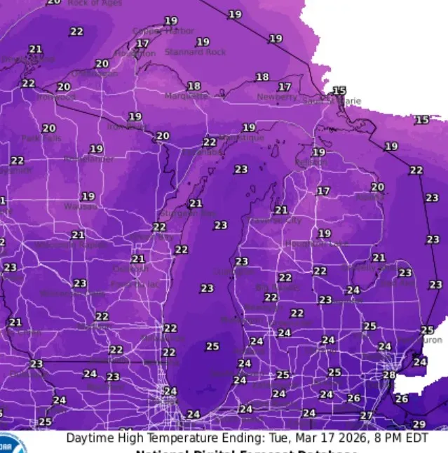
Finally, here are the high temperatures for St. Patrick’s Day (Tuesday, March 17). Shiverin’ Shillelaghs! These highs are about 20 degrees colder than average — just mid-20s with a few spots in northern Lower and Upper Michigan failing to reach 20 degrees.
By the way, the coldest high temperature ever in Grand Rapids on St. Patrick’s Day was 10 degrees in 1941. We won’t be that cold.
FUN FACT: The all-time Michigan record for season snowfall is 390.4 inches near the town of Mohawk in the Keweenaw Peninsula of Upper Michigan. That was during the winter of 1978-79.
— Check out Bill Steffen's Substack channel.


