
As America celebrates, 250 million under dangerous heat dome. Get the weekend forecast
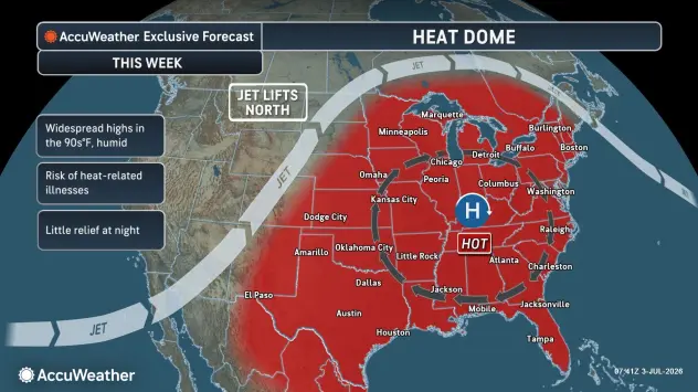
Dangerous conditions will build for more than 250 million people in the central and eastern United States this week — including the Fourth of July — as days of extreme temperatures, high humidity and intense sunshine combine under a massive heat dome.
A major heat wave will grip close to three dozen states in the days leading up to the Fourth of July and could put millions at risk for heat-related illness.
Dangerous conditions will build for more than 250 million people in the central and eastern United States this week — including the Fourth of July — as days of extreme temperatures, high humidity and intense sunshine combine under a massive heat dome.
The heat wave will bring the hottest weather so far this year for many, and in some cases, the worst in years.
More extreme heat is coming on Saturday.
Temperatures over 100 F
Persistent temperatures this high can cause roads and rails to buckle, potentially leading to transit problems. Daytime temperatures near the ground can be dozens of degrees higher than the official 6 feet or so off the ground, where forecasts are intended.
Official temperatures this week will be 10-20 degrees above the 30-year historical average in nearly three dozen states in late June and early July.
"The extreme heat and humidity are expected to bring near-record, or record-breaking, energy usage to the mid-Atlantic power providers," AccuWeather Senior Meteorologist Alan Reppert said.
As the sun beats down on pavement and brick buildings, these surfaces absorb heat during the day and slowly release it at night, making conditions in urban cities unbearable, if not life-threatening, without air conditioning. Temperatures in many of the major cities may not drop below 80 degrees at night.
Record warm nights will occur along with record daytime highs. New York City may have three consecutive nights with temperatures not dropping below 80, which is very rare. Temperatures did not drop below 82 in New York's Central Park on Thursday morning.
The exclusive AccuWeather HeatWave Counter and Severity Index shows that several major cities in the Northeast, Midwest and interior South are facing a notable stretch of dangerous heat in the days leading up to and including the Fourth of July holiday.
5-day forecast
- Friday: Ottawa County remains under a heat advisory until 8 p.m. Friday, July 3, indicating heat index values up to 100 degrees. Uncomfortably humid with clouds and sun; a heavy thunderstorm this afternoon, which could bring flooding downpours, hail and damaging wind gusts. High: 81 degrees. Tonight, overcast and humid with a couple of showers and a thunderstorm; heavy downpours can reduce visibility and cause ponding on streets and highways. Low: 69 degrees.
- Saturday: Intervals of clouds and sunshine with a heavy thunderstorm; humid; thunderstorms can bring flooding downpours, hail and damaging wind gusts. High: 83 degrees. Saturday night, expect partly cloudy skies and humid conditions with a couple of showers and thunderstorms. Low: 62 degrees.
- Sunday: Mostly cloudy and humid with a couple of showers and thunderstorms. High: 76 degrees. In the evening, mostly cloudy with a couple of thunderstorms. Low: 62 degrees.
- Monday: Mostly cloudy. High: 78 degrees. In the evening, expect partly cloudy skies. Low: 63 degrees.
- Tuesday: Mostly sunny and humid. High: 82 degrees. In the evening, mainly clear with a low of 64 degrees.
— Check out Bill Steffen's Substack channel.


