

Weather outlook: First half of September looks warmer than average. Get Bill Steffen's forecast
The U.S. Weather Service is forecasting warmer-than-average temperatures in Michigan and for much of the country into mid-September.

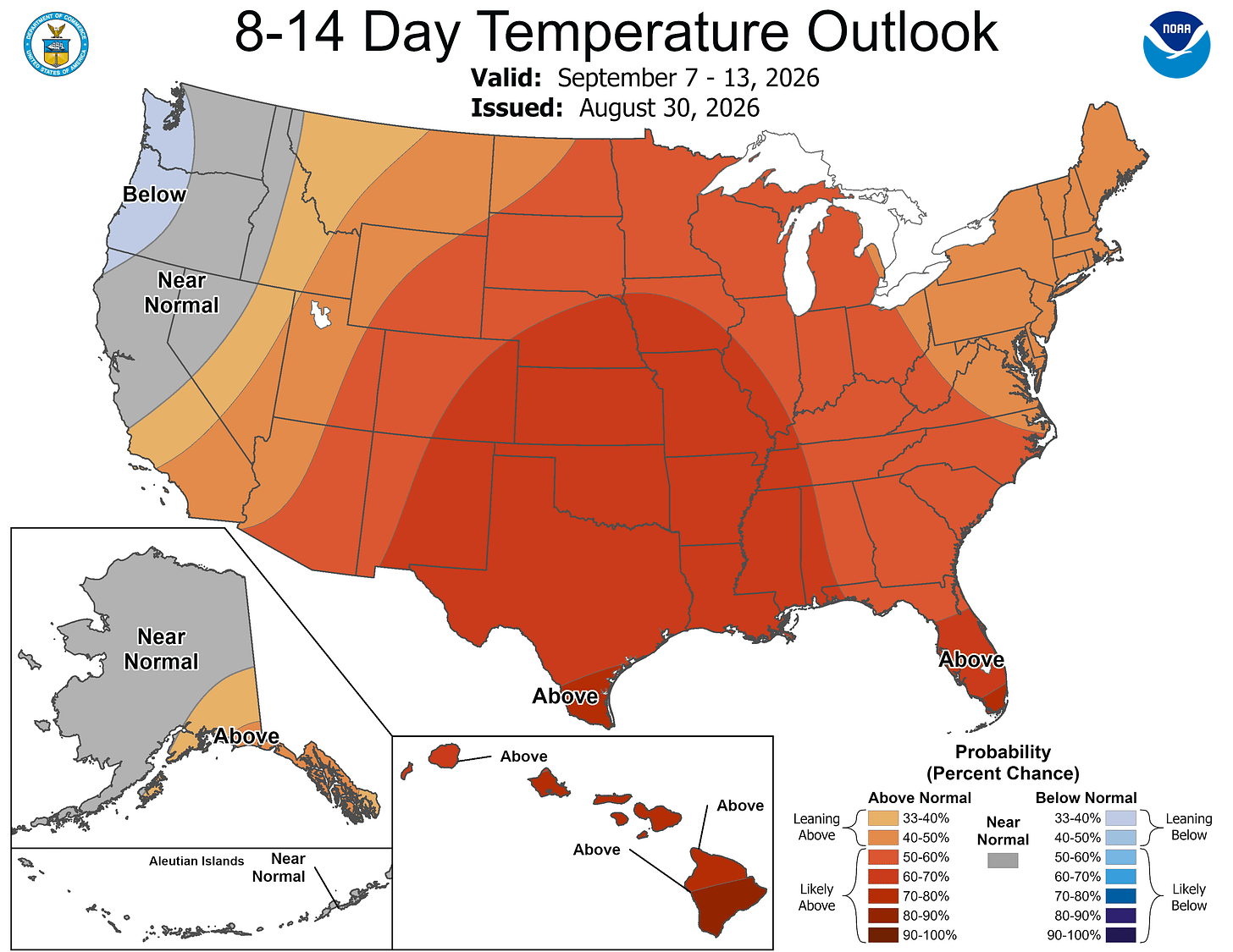
The computer models have been quite consistent — forecasting warmer-than-average temperatures in Michigan and for much of the country into mid-September.
We may start calling this pattern “endless summer.” There will be a “heat dome” or “heat ridge from the Plains into the Southeast.
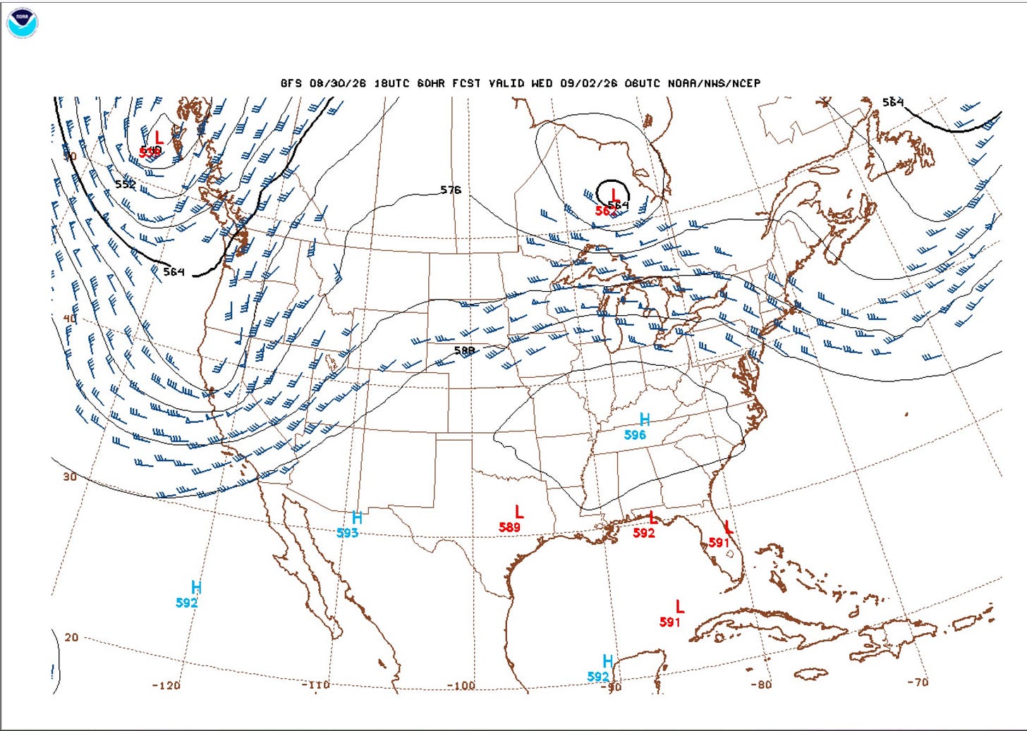
Here’s the forecast upper air flow for Sept. 2. There’s a trough along the West Coast. This should bring showers down into northern California. The warm, high-pressure ridge extends from Texas and New Mexico to the mid-Atlantic states.
Often there are thunderstorms (a few with strong to severe wind gusts) along the periphery of the ridge, which may include Michigan. Here the wind has to squeeze together and speed up as it passes between the Low in Canada and the High along the KY/TN border. Low pressure in Florida and along the Gulf should bring a few rounds of thunderstorms there.
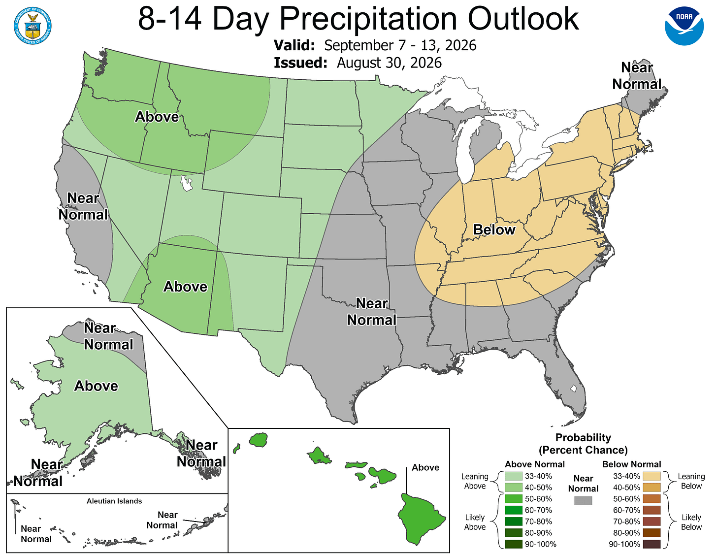
The 8-14 day rainfall outlook has above-average rainfall from the mountains of Mexico up into much of the western U.S. Alaska and Hawaii may also be on the wet side.
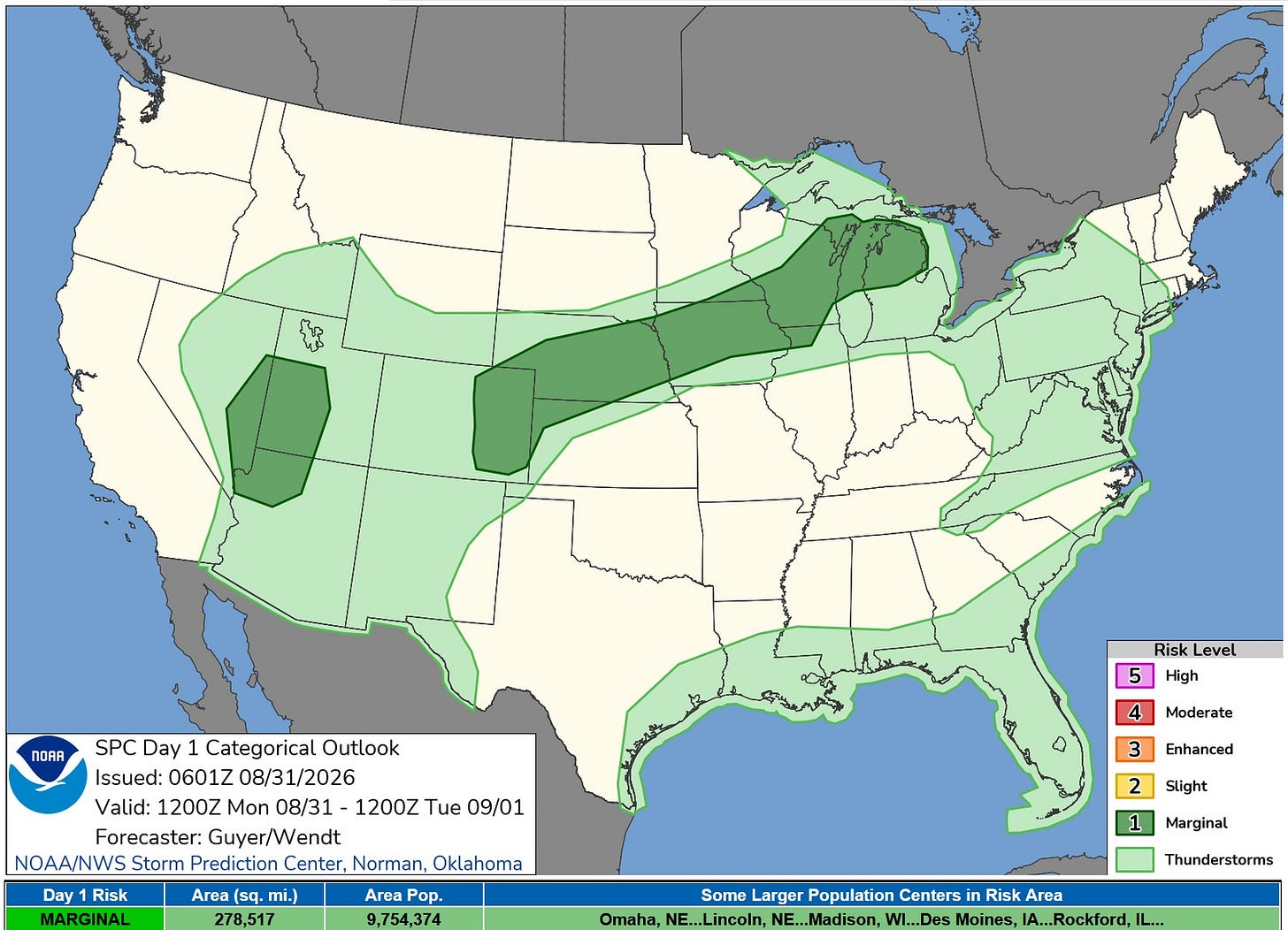
This is the Severe Weather Outlook Map for today/tonight. There is a Marginal Risk of strong winds in storms north of U.S. 10 in Lower Michigan.
SPC says: “… Isolated activity is possible from Iowa into northern Illinois/northern Michigan late tonight.”
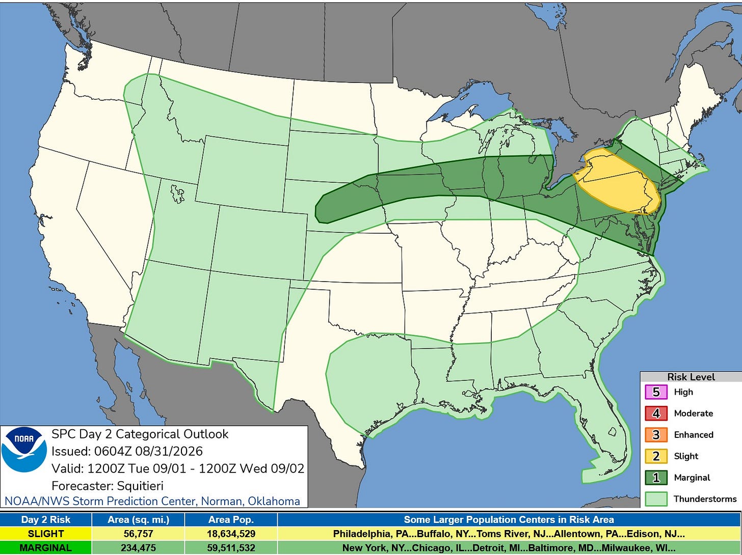
The Severe Weather Outlook Map for Tuesday and Tuesday night shows a Marginal (level 1) risk from U.S. 10 to the south.
SPC says: “Given the strong overlapping buoyancy and vertical wind shear, any storm that can mature and become sustained may become multicellular or supercellular, accompanied by a severe wind/hail threat. At the moment, storm coverage should be sparse, since upper support with the Great Lakes mid-level trough should only graze the warm frontal zone, and the approach of the central Plains impulse should occur late in the period. Therefore, despite the favorable convective environment, probabilities have been maintained at Category 1/Marginal Risk.”
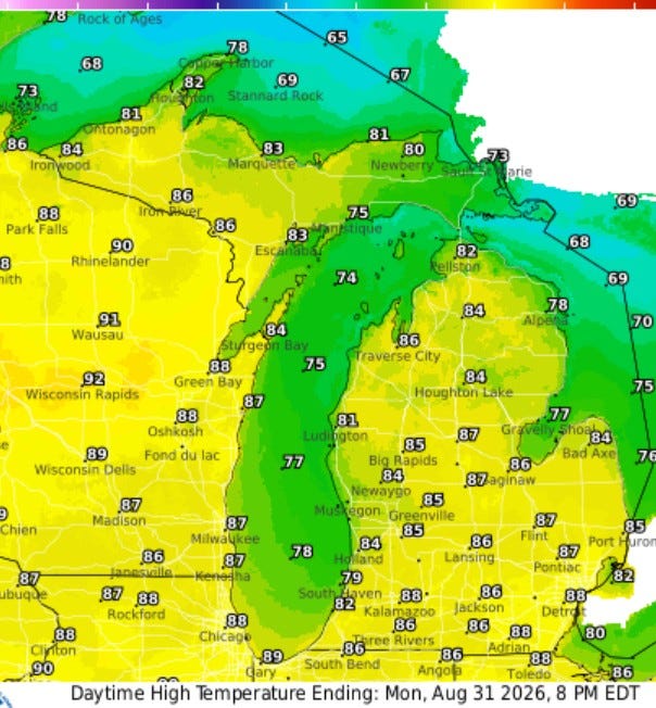
We’ll end August with a warm and rather humid day. High temperatures will reach the mid- to upper 80s in inland areas and mid- to upper 70s at Lake Michigan. The warm air extends north to Lake Superior. Temperatures will climb to the low-mid 80s in Upper Michigan.
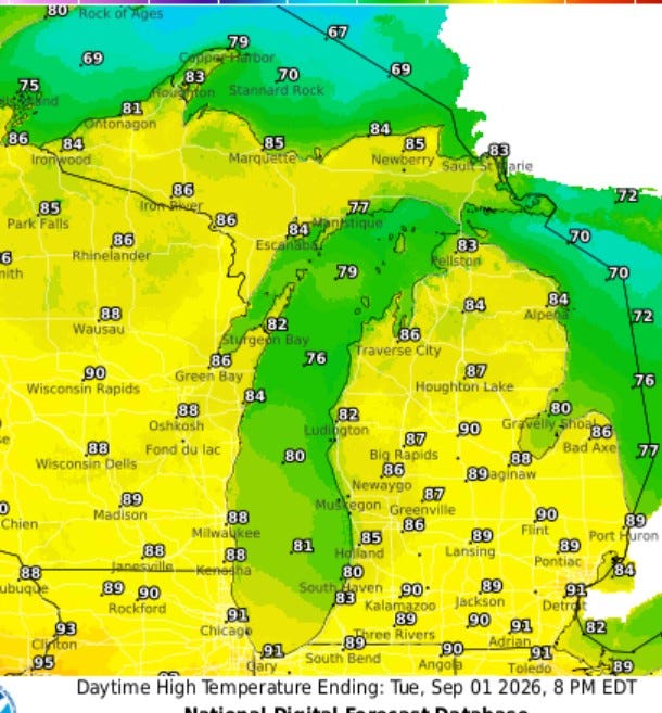
A few inland areas could reach 90 degrees on Tuesday afternoon and Wednesday afternoon. It could reach 80 at the Lake Michigan beaches both days and mid-80s in the U.P.
Five-day forecast
- Monday: A couple of morning showers and a thunderstorm; otherwise, rather cloudy, breezy and humid. High: 84 degrees. Tonight, partly cloudy, warm and humid with widely separated thunderstorms. Low: 70 degrees.
- Tuesday: Warm and humid with intervals of clouds and sunshine; a thunderstorm in spots in the afternoon; any thunderstorm can cause flash flooding and damaging winds. High: 82 degrees. In the evening, expect similar conditions. Low: 72 degrees.
- Wednesday: Sun and some clouds, breezy, very warm and humid with a stray thunderstorm. High: 86 degrees. In the evening, partly cloudy, warm and humid; an evening thunderstorm followed by a couple of showers late. Low: 67 degrees
- Thursday: Intervals of clouds and sunshine with a thunderstorm; warm and humid. High: 83 degrees. Warm and humid with thickening clouds; a thunderstorm in spots in the evening followed by a couple of showers late. Low: 66 degrees.
- Friday: Remaining warm with sun breaking through clouds at times; a thunderstorm in spots in the afternoon. High: 82 degrees. In the evening, expect partly cloudy skies, with a strong thunderstorm in spots late. Low: 64 degrees.
— Subscribe to Bill Steffen's Substack.


