
Heat, humidity finally set in. Get Bill Steffen's weekday forecast
Humidity is projected to rise above this week's low-to-moderate levels.
"The jet stream pattern will shift quickly this week. Unlike previous episodes that sustained cooler weather for several days, this dip in the jet stream will move through in only 24-36 hours," AccuWeather Senior Long-Range Meteorologist Joe Lundberg said.
"It will be followed by a pronounced northward bulge, allowing much warmer air to return."
After what should be the coolest day of the week for most areas on Monday, temperatures will again trend upward. This time, humidity is projected to rise above this week's low-to-moderate levels.
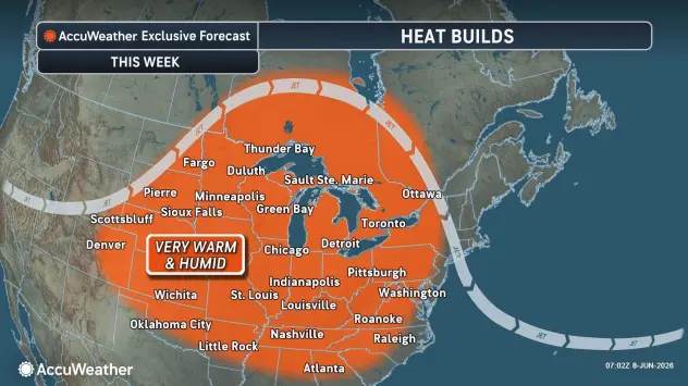
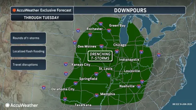
Temperatures will rise quickly, with highs ranging from the mid-80s to the upper 90s by the middle of the week. Meanwhile, repeated rounds of showers and thunderstorms are expected across portions of the Mississippi and Ohio valleys. Where the downpours persist in this zone, the risk of flash flooding will be greatest.
5-day forecast
- Monday: The temperature near the record of 89 from 2020 with periods of sun; breezy this morning, then a thunderstorm in spots late this afternoon. High of 87 degrees. Low of 69 degrees.
- Tuesday: Cloudy and not as warm but humid with a couple of showers and a heavy thunderstorm. High of 75 degrees. Low of 63 degrees.
- Wednesday: A morning thunderstorm; otherwise, intervals of clouds and sun, breezy and warmer, becoming humid in the afternoon. High of 84 degrees. Low of 66 degrees.
- Thursday: Mostly cloudy and humid with a strong thunderstorm in spots; breezy in the morning; there can be damaging winds, hail and even an isolated tornado. High of 81 degrees. Low of 61 degrees.
- Friday: Plenty of sun, pleasant and less humid. High of 74 degrees. Low of 61 degrees.
— Check out Bill Steffen's Substack channel.


