


New trails, restrooms and 185 acres of open space: What's new at Ottawa County Parks
With miles of new trails breaking ground, a 185-acre park expansion newly opened to the public, and fresh facility upgrades underway, Ottawa County Parks and Recreation is making a major push this fall to connect communities and enhance the region's great outdoors.

OTTAWA COUNTY — With miles of new trails breaking ground, a 185-acre park expansion newly opened to the public, and fresh facility upgrades underway, Ottawa County Parks and Recreation is making a major push this fall to connect communities and enhance the region's great outdoors.
“There's a mix of opportunities, and all of them are intended to make the places people already visit more enjoyable,” said Riley Dorman, communications specialist at Ottawa County Parks and Recreation.
The projects below will be completed with or without the upcoming Ottawa County Parks and Recreation millage approval, with additional projects being added to the docket if the millage increase gets approved. Read more about the Ottawa County Parks millage at this link.
Idema Explorers Trail segments
Construction is officially underway on over 6 miles of trails on the Idema Explorers Trail, including the Bass River and Eastmanville Bayou segments. Work on these segments is part of a larger project: a planned 36.5-mile nonmotorized trail that will eventually connect Grand Haven to Grand Rapids.
The first of a four-phase plan for the Bass River segment is nearing completion in Robinson and Allendale charter townships. Ottawa County Parks leads the project in partnership with the Michigan Department of Natural Resources.
The full 7.4-mile Bass River segment will eventually connect Riverside Park, Bass River State Recreation Area and Eastmanville Bayou through nearly 2,000 acres of parkland.
Phase 1 has been supported by the Michigan DNR, the federal Land and Water Conservation Fund, and the Parks and Open Space Millage.
Phase 2 has been signed and approved regarding engineering services, and engineering design is expected to begin soon, with construction starting in 2027. Phase 2 will mark the start of 0.7 miles of construction from the Max Bayou boat launch area to the Bass River Open Space – Walcott Site.
Work on the Eastmanville route has also begun. This segment will follow 60th Avenue and Lincoln Street, descend the former 61st Avenue right-of-way to the river, and continue west through Eastmanville Bayou to the park entrance at 68th Avenue. The separate 3-mile section will connect Allendale Township neighborhoods to Eastmanville Bayou and the Grand River.
Expected to be completed in spring 2027, it will form an eventual 9-mile, largely off-road trail corridor extending west to Bass River State Recreation Area.
The Allendale segment of the project is expected to start construction in 2028-2029. The Transportation Alternatives Program funding application remains under review, and Ottawa County Parks and Recreation (OCPR) is responding to requests for additional information. Currently, OCPR’s engineering consultant is in the process of securing the required state wetland permit.
Bend Area expansion open to the public
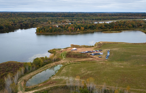
The 185-acre Bend Area expansion (1600 Fillmore St., Jenison) officially opened to the public Oct. 14. A designated parking area and trail signage are now available on-site.
Community input sessions will be available to kick off an update to the area's master plan. The first input session is at 5:30 p.m. Dec. 1 at the Georgetown Township Board Room, 1515 Baldwin St., Jenison, and will help guide future improvements on the property.
To sign up for emails about future input sessions, visit this link.
Kitchel-Lindquist-Hartger Dunes to P.J. Hoffmaster
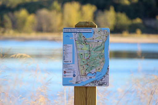
There is officially a new trail connection through the Grand Haven dunes. The new 1.1-mile Grand Haven Dunes Connector Trail links Kitchel-Lindquist-Hartger Dunes Preserve to Ottawa Sands County Park. From there, hikers can follow existing trails.
Ottawa County Parks and Recreation staff completed trail clearing and signage in early October as part of the larger Lake Michigan Coastal Greenway.
What hikers should know:
- The connector is a natural surface trail with loose sand and uneven terrain. Hikers should wear sturdy footwear, bring water and allow extra time to navigate the new route.
- Trail maps for the sections can be found below:

New restroom at Upper Macatawa Natural Area
Construction is officially underway on a new modern restroom at the 84th Avenue entrance to Upper Macatawa Natural Area. Along with that, several other improvements have been made at Hawthorn Park, such as a parking expansion, improved security and the new Middle Macatawa Connector.
The connector is a 2.1-mile natural surface trail connecting Upper Macatawa Natural Area and Hawthorn Park along the Macatawa River Greenway.
— Mallory Burt is a reporter for Ottawa News Network. Contact her at newsroom@ottawanewsnetwork.org.


