

Strong storms will move south with pleasant weekend expected. Get Bill Steffen's forecast.
On Friday afternoon and night, the risk of severe weather will ease for parts of the Upper Midwest.

The parade of storms will continue across portions of the Midwest and mid-Atlantic, bringing additional rounds of severe weather and flash flooding. The rounds of storms will shift southward along the Atlantic coast and will reach some of the northeastern Gulf Coast states this weekend.
Storm after storm swept from the Great Lakes through parts of the Appalachians to the mid-Atlantic coast from Wednesday to early Friday. Some of the storms brought powerful wind gusts that knocked down trees and caused property damage.
Storms from Wisconsin to the Lower Peninsula of Michigan at the start of the day on Friday were producing torrential rain and flash flooding with only isolated gusty winds.
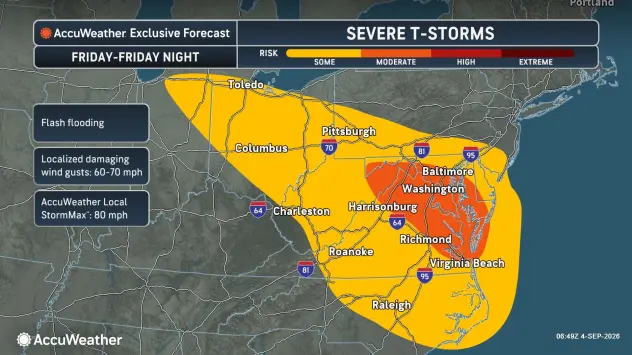
On Friday afternoon and night, the risk of severe weather will ease for parts of the Upper Midwest and much of Pennsylvania, New York and New Jersey, but focus farther south from areas in southern Pennsylvania, Ohio, the Appalachians and the Atlantic Seaboard.
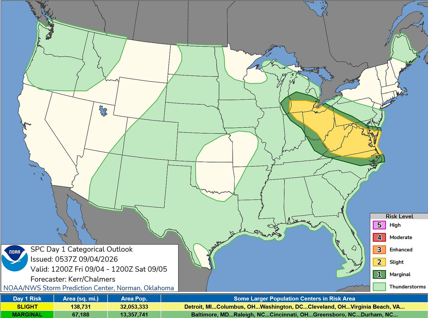
Here’s the Severe Weather Outlook Map from the Storm Prediction Center for this Friday. Strong thunderstorms that have been moving through eastern Wisconsin will move through West Michigan this morning.
Much of the midday and afternoon could turn out to be dry, but there is still a chance of a storm during the afternoon.
The level 2 Slight Risk is along and south of I-96, extending from West Michigan to the Atlantic Ocean.
The National Weather Service's Storm Prediction Center says: “Latest convection allowing guidance suggests that a front may already be providing a focus for organizing thunderstorm development across southern Lower Michigan…potential to produce strong to severe wind gusts while propagating southeastward across parts of northern/eastern Ohio into the Allegheny Plateau by this afternoon.”
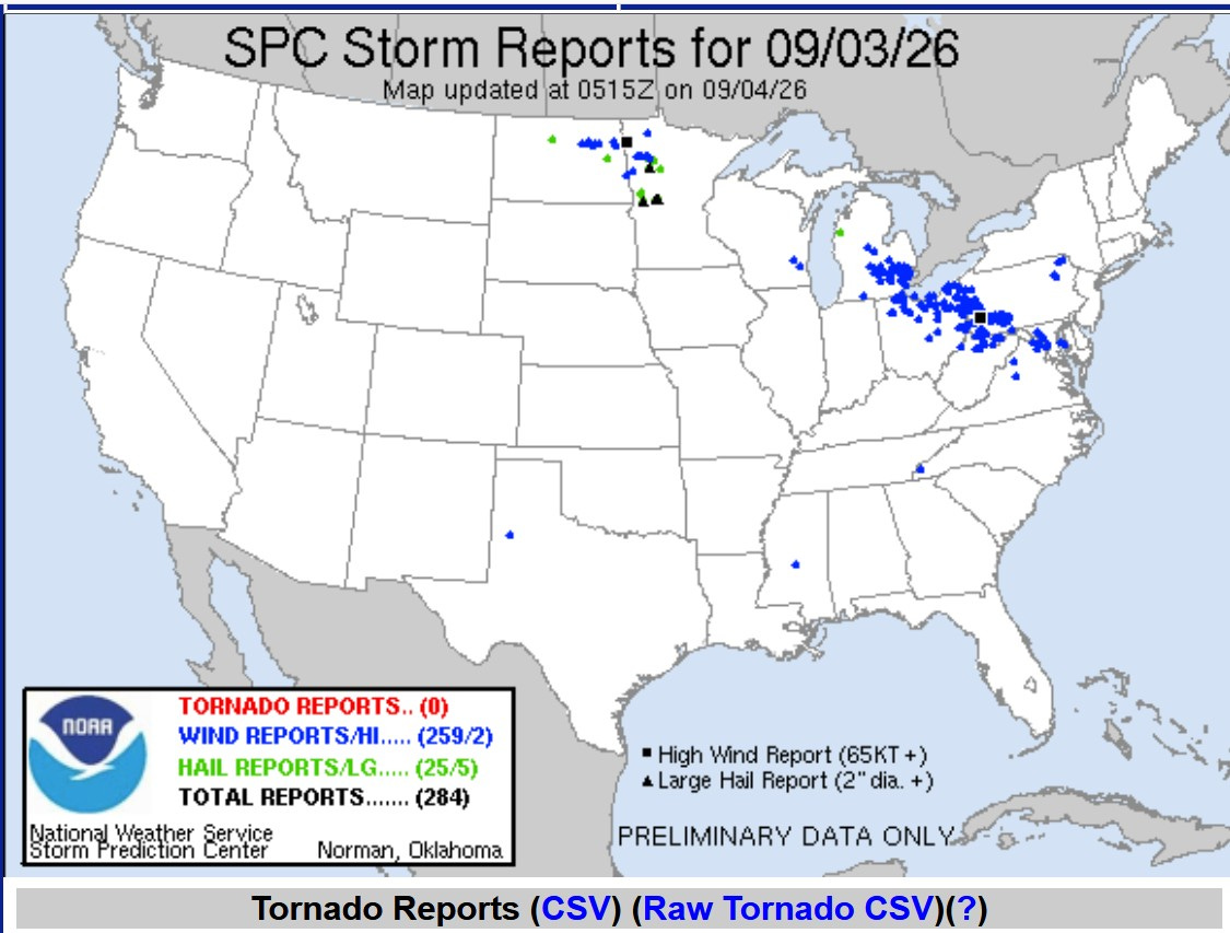
Here are storm reports from Thursday as of 2:30 a.m. Friday. Severe thunderstorms formed along US 127 (Lansing-Mt. Pleasant) and pushed through southeast Michigan and into Ohio and western Pennsylvania. No tornadoes, but there were 259 reports of wind damage.
There were a lot of 50-65 mph wind gusts that downed many trees in southeast Michigan. A carport was damaged near Mt. Pleasant, nearly 100 trees were downed near Lake Lansing and there was some building damage near Comerica Park in Detroit.
As of 1:20 a.m., there were 263,143 customers without power in Michigan, by far the most of any state.
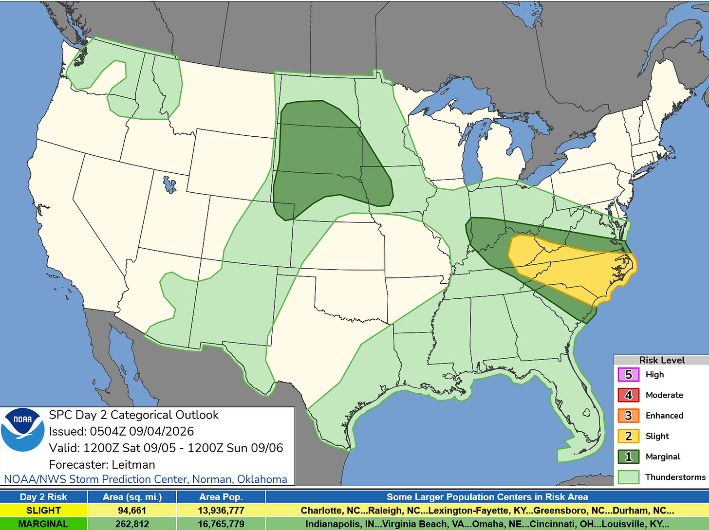
This is the Severe Weather Outlook Area for Saturday. While I can’t rule out a shower or isolated storm Friday night, the period from Saturday through Monday looks dry and pleasant over most of Michigan.
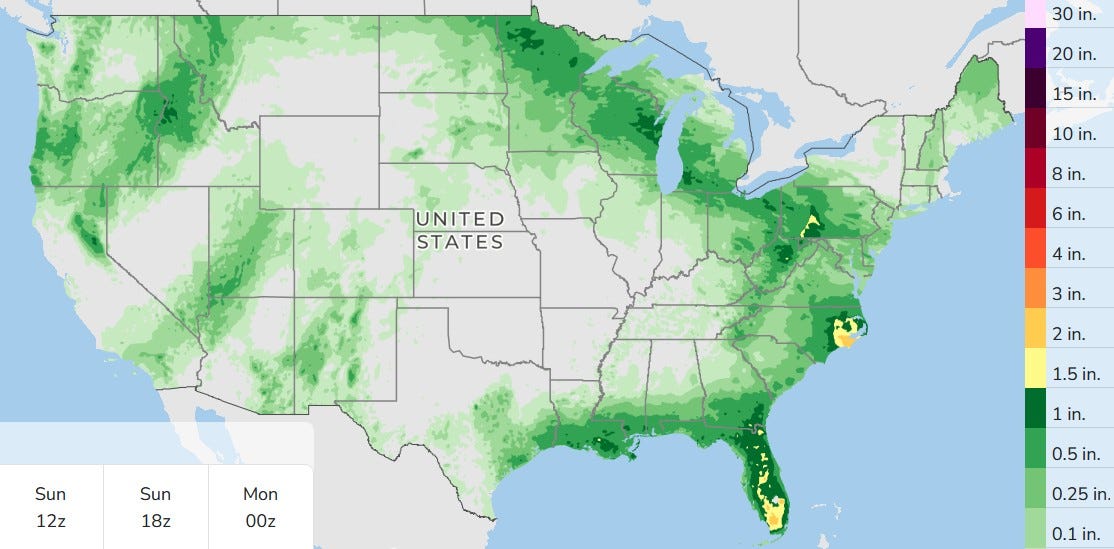
This is the three-day total rainfall, but it does include rain that fell Thursday afternoon and evening. The remains of tropical storm Edouard are still visible in Texas, though it’s just a few light showers.
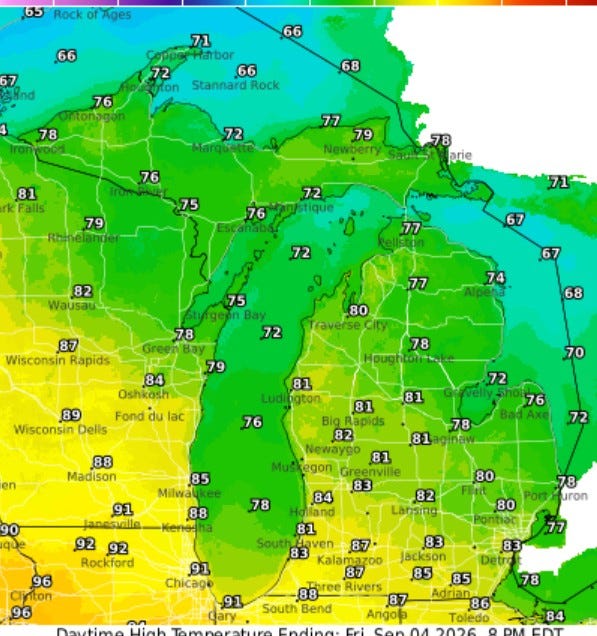
High temperatures today will reach the mid-80s inland and mid- to upper 70s near Lake Michigan. Readings should be in the pleasant 70s in northern Lower and Upper Michigan.
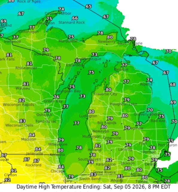
Saturday will be several degrees cooler than today, and the humidity will start to go down a bit during the afternoon.
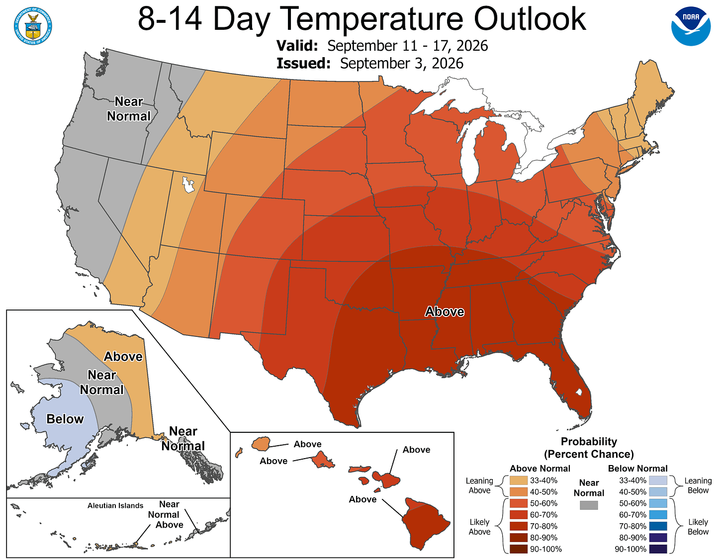
No sign of any change in the overall pattern, highlighted by a strong El Niño. The heat ridge remains anchored from the Great Lakes to the South.
Now, average temperatures will be going down, but the overall pattern should keep us warmer than average through much of September.
Five-day forecast
- Friday: Some sun with a couple of heavy thunderstorms, especially early; warm and humid; flash flooding from persistent downpours could lead to dangerous travel conditions. High: 82 degrees. Tonight, cloudy, warm and humid with a thunderstorm.
- Saturday: Times of clouds and sun with a thunderstorm in spots; humid. High: 80 degrees. In the evening, clear with a low of 58 degrees.
- Sunday: Mostly sunny, pleasant and less humid. High: 78 degrees. In the evening, mainly clear with a low of 58 degrees.
- Monday: Partly sunny with a high of 78 degrees. In the evening, mainly clear with a low of 63 degrees.
- Tuesday: Cloudy with a high of 80 degrees. In the evening, mostly cloudy, warm and humid with a late-night shower. Low: 70 degrees.
— Subscribe to Bill Steffen's Substack.


