
Rain returns today. Get Bill Steffen's weekend forecast
The weekend will be dry and storm-free in Michigan, but we’ll have to keep an eye out for Monday afternoon/evening.
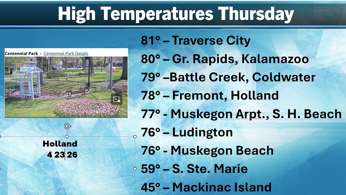
Here are the high temperatures from Thursday.
Look at the top temperature and the bottom temperature. Traverse City reached a warm 81, while not all that far away, Mackinac Island had a high temperature of just 45. Traverse City had a warm, south wind off the land, while Mackinac Island had a damp, brisk east wind off Lake Huron.
It was the first 80-degree temperature of the year for Grand Rapids, and probably the warmest day we’ll see for maybe a couple of weeks. Nice pic. here courtesy of the city of Holland. Overall, the weather should be cool and pleasant for Tulip Time.
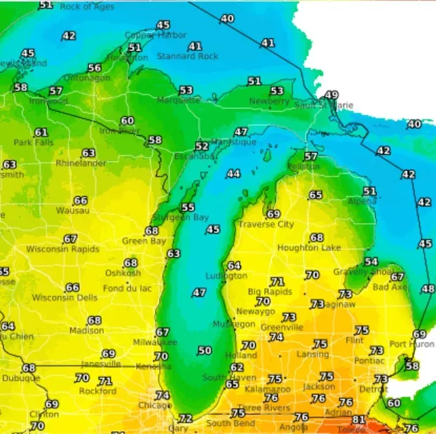
Here are the high temperatures for this afternoon. We’ll be a few degrees cooler than yesterday because of more clouds and a chance of a shower or thunderstorm. Winds will shift from the south early to the west off Lake Michigan, so temperatures may drop a few degrees when that happens.
South Haven gets a high of 62 ... and just 47 in the U.P. at Manistique, where the south wind will be coming off Lake Michigan. That’s an interesting place. Sometimes a cold front will come through Manistique, and the temperature will go up a few degrees as the wind shifts from the south off Lake Michigan to the west off the land.
Speaking of the U.P., Marquette was down to 1 inch of snow on the ground at midnight. That inch will melt today, leaving just the remains of the snow piles near the airport. They’ve had snow on the ground every day since Nov. 25. The town of Herman still had 11 inches on the ground Friday morning, but I bet much of that melted with the temperatures yesterday in the 60s.
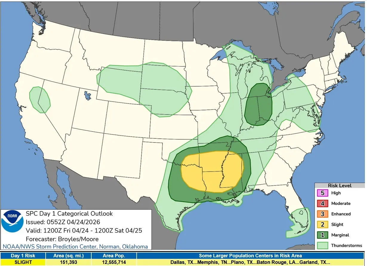
Here’s the Severe Weather Outlook Map from the Storm Prediction Center for this Friday. SPC has added a Marginal Risk Area for southern Lower Michigan away from Lake Michigan and for much of Indiana and western Ohio.
SPC says: “A moist airmass will be in place from the Lower Ohio Valley northward into lower Michigan. As surface temperatures warm during the day, surface dewpoints in the lower 60s will contribute to weak destabilization. This, combined with increasing low-level convergence, will support thunderstorm development ahead of the front. These storms will move eastward across the southern Great Lakes and Ohio Valley during the afternoon. Forecast soundings ahead of the storms have very steep low-level lapse rates approaching 8 C/km, which could support an isolated wind-damage threat.
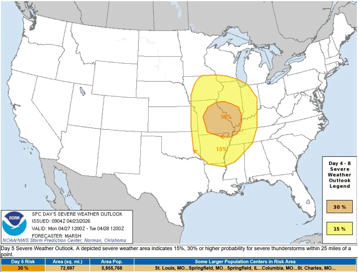
The weekend will be dry and storm-free in Michigan, but we’ll have to keep an eye out for Monday afternoon/evening. This is the Severe Weather Outlook Area for Monday night. The 15% (level 2 risk) comes up to Berrien County. The rest of our area could be at a level 1 risk.
5-day forecast
- Friday: Considerable cloudiness and not as warm with a couple of thunderstorms, with a high of 66 degrees. Tonight, expect a couple of evening showers; otherwise, overcast and cooler, with a low of 42 degrees.
- Saturday: Clouds will give way to sun, with temperatures dropping. Expect a high of 61. In the evening, expect mostly cloudy skies with a low of 41 degrees.
- Sunday: Partly sunny and pleasant with a high of 67 degrees. In the evening, expect partly cloudy skies and breezy conditions, with a low of 48 degrees.
- Monday: Mostly cloudy and windy; a thunderstorm in the afternoon, with a high of 70 degrees. In the evening, there will be increasing winds with periods of rain and possibly a thunderstorm. The low will be around 51 degrees.
- Tuesday: Mostly cloudy, windy and cooler with a high of 57 degrees. In the evening, it will be breezy; otherwise, it will be partly cloudy with a low of 44 degrees.
— Check out Bill Steffen's Substack channel.


