
Storms to return midweek. Get Bill Steffen's weekday forecast
An area of low pressure and associated front will interact with a surge of moisture, setting the stage for possible severe weather.
The storm-weary Midwest will face another threat of severe weather by the middle of the week.
An area of low pressure and associated front will interact with a surge of moisture, setting the stage for possible severe weather.
"Many communities in the Midwest are still in the early stages of storm cleanup from this past week’s thunderstorms, and the upcoming weather pattern will result in many of the same locations facing similar risks," said AccuWeather Meteorologist Brandon Buckingham.
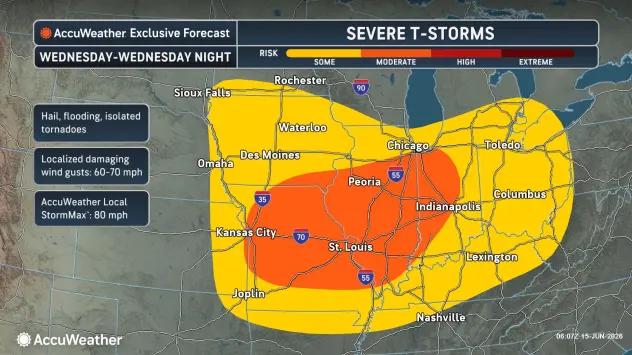
Severe storms can occur from far eastern Nebraska and Kansas into much of Ohio, southern Michigan and western West Virginia. AccuWeather meteorologists have highlighted much of Missouri, Illinois and western Indiana with a moderate risk of severe weather where storms can be most numerous.
Hazards, including hail, damaging wind gusts and isolated tornadoes, can occur in any storm that turns severe.
5-day forecast
- Monday: Breezy with partly sunny skies. High: 70 degrees. Tonight, partly cloudy with a low of 61 degrees.
- Tuesday: Mostly cloudy and windy with a couple of showers and a thunderstorm; gusty winds and small hail are possible. High: 68 degrees. Tuesday night, windy and partly cloudy with a couple of showers. Low: 56 degrees.
- Wednesday: Variable cloudiness, becoming windy in the afternoon with a couple of showers and a thunderstorm. High: 67 degrees. In the evening, expect periods of rain and windy conditions. Low: 57 degrees.
- Thursday: Times of clouds and sun with a couple of showers; breezy. High: 67 degrees. Thursday night, expect mainly clear skies with a steady breeze. Low: 57 degrees.
- Friday: A steady breeze with sunshine and a few clouds. High: 69 degrees. Friday night will be mainly clear. Low: 57 degrees.
— Check out Bill Steffen's Substack channel.


